GPS Basics

My first and most memorable GPS failure happened many years ago while I was doing a little pre-hunt scouting. My brother and I had located a small pond on a secluded pine bench and wanted to check the elk activity. The 4-wheeler trail stopped about a mile short of the pond, and with the sun beginning to set, we set out in a hurry to cover the distance before dark. In our haste, my brother forgot to start the GPS and mark the location of the 4-wheeler. Once in the thick pines, the GPS unit had a hard time getting a signal. He eventually got a signal and thought he marked a waypoint. We made it to the pond, checked for sign, and then continued up the ridge to look into a big canyon until dark. As we headed back down the ridge to the 4-wheeler, we quickly realized that we weren’t prepared. It was getting dark fast and in our hurry to get on the trail we had forgotten our headlamps. We had a new moon and very little starlight, which made for one of those pitch-black evenings. We weren’t lost, but didn’t know exactly where we were in relation to our 4-wheeler. My brother whipped out his GPS to track us back to the waypoint that he thought he marked earlier.
With the little bit of light from the GPS screen we tried to navigate the brushy mountainside. We wandered around in the dark for about an hour trying to find our 4-wheeler. The GPS was telling us to go one way and my instincts were telling me to go a totally different direction. It was very frustrating. Not long into our search, his GPS ran out of battery and to make a long story short, we wandered around in the dark for another hour before we finally found our ride home. I vowed from that time forward I was going to learn how to use a GPS and be more prepared anytime I ventured into the woods.
Since our first bad experience, GPS technology has come a long way and I have learned to use a bunch of cool features that have helped me become an extreme elk hunter. Some of you fellow elk hunters may be very comfortable using a GPS; some of you may be a little reluctant to navigate your backcountry adventures using modern GPS technology. Whatever the case may be, hopefully some of the content of this article will hit home and be useful the next time you venture into the elk woods.
Which GPS to Buy?
There are a lot of great GPS units on the market today so I am not going to recommend a specific GPS to purchase. That decision really depends on your own personal preferences and budget. You can get a decent GPS for as little as $100 bucks all the way up to $700 plus. I am currently using the Garmin 62 series GPS. The model I use is the GPSMAP 62s. There are several different models of the 62 series but I chose the “S” model because it didn’t come preloaded with the standard 1:100K topographic (topo) maps. I chose to buy and load the 1:24K scale maps on my GPS. The 1:24K maps give you more detail but also take up more memory space so there are trade offs. For example, you can get the entire U.S loaded on your GPS with the 1:100K scale maps whereas you can only get a few states with the 1:24K scale maps using the same amount of memory storage. My brother uses the Garmin 60CSX which has been a great workhorse unit for several years and is hard to beat.
 Some of the key features to consider when shopping for a GPS are:
- Size of display
- Color screen
- Touch screen
- Internal memory
- Accepts data cards
- High-sensitivity receiver
- Electronic Compass
- Barometric altimeter
- Waterproof
- Camera
- Wireless data sharing
- Includes topographical maps
Here is a link to the latest and greatest mapping handhelds available from Garmin. You can compare the different models side by side on the Garmin website as shown in the adjacent chart.
Click here to see the options.
Tip 1 – Spend time learning how to use your GPS
More than just reading the owners manual (although I do recommend that), take time to learn the features and functionality of your unit. For instance, how long does it take to acquire a satellite signal? How long is the battery life under extreme conditions (most of the time what is published is not reality)? How many waypoints or routes can you store on the units internal or external memory? Is your unit waterproof? Can you load maps onto your unit? There are several more questions you should know about your GPS before you get into the heat of battle on your elk hunt. The best way to learn is to do. Take it with you on your scouting trips, to your kids’ soccer games, etc. Bottom line: become very familiar with how to use it.
Tip 2 – Your GPS is only as good as the batteries that power it
The battery life on most GPS units will last approximately 15-20 hours of normal use. Make sure you always have an extra set of batteries in the field. I typically use lithium-ion batteries because they are much lighter and seem to last longer. However they are a little more expensive.
Tip 3 – Use advance features of mapping software
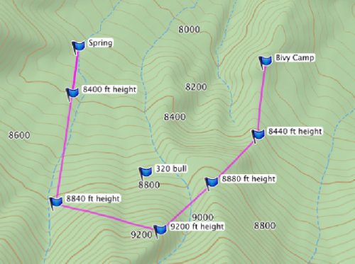
 If you have spent much time at hunting expos, you are probably aware that there are several companies out there that provide mapping software for GPS units. Some of these maps show Game Management Units, BLM Lands, National Forest, and even private property boundaries. The most common maps loaded onto GPS’s are USGS TOPO maps and these can be found and downloaded from Garmin’s website. These USGS TOPO maps are available by region as well as two different scale options (1:100K and 1:24K). As mentioned earlier, the 1:24K scale contains more detail than the 1:100K scale and therefore requires more memory on your GPS. I picked the U.S. TOPO 1:24K Southwest DVD which covers UT, CO, AZ, and NM. Depending on the region selected, you have flexibility to download as little or as much of the map area as you would like. For example, I was hunting Southern Colorado last year so I downloaded only that portion of the state for that particular hunt. Also, I typically load all of my maps onto the removable micro SD card on my GPS and utilize the internal memory for waypoints, routes, etc. Other software applications available from Garmin are BaseCamp and Trip and Waypoint Manager. These applications can be downloaded to your PC. I use both of these applications to survey the terrain and plan routes on the larger screen of my laptop or desktop and then I can download directly to my GPS.
Tip 4 – Always mark your starting point
 Whether you are hunting on horseback, 4-wheeler, truck, bivy camp, or a base camp, it will save you a lot of time and headache finding your way back (especially in the dark), if you accurately marking your origination point. Turn your GPS on right when you get to your hunting area so by the time you have your gear ready to go, your GPS should have acquired a satellite signal. Simply mark a waypoint and you’re on your way.
Tip 5 – Have a back up plan
Technology is awesome, but it has been known to fail from time to time especially under extreme conditions. I always take a compass and map of the area I am hunting just in case. Typically, my backup compass is my Suunto watch. I always double-check my bearings even when I am using my GPS to make sure both are telling me the same thing. This is especially important if you are hunting a new area or heavily timbered country where landmarks aren’t as easy to identify.
Like I mentioned in the beginning, using a GPS has totally changed the way I hunt and I believe has made me a more efficient and deadlier hunter. If I have trail cameras I need to check at night or I want to get to a tree stand or get into position before light, my GPS has been invaluable. Elk are tough, smart animals. We need to use every advantage we can!
